


























The fact that Africa appears much smaller on maps than its actual size was a design choice born out of 16th-century navigational needs. However, the visual proportions offered by the map laid the groundwork for the geographic and symbolic “diminishment” of the Global South for centuries.
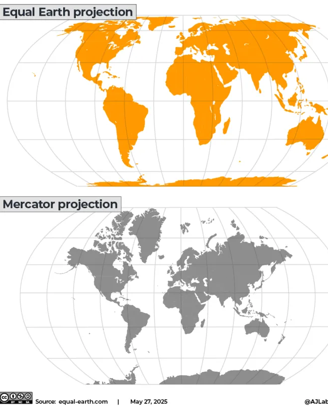
Widely used today in everything from educational materials to digital platforms, the Mercator projection preserves directions and angles while severely distorting the area proportions of landmasses. Situated along the equator, the African continent is the region that remains closest to its true scale in this projection system. In contrast, as one moves away from the equator toward the poles, landmasses artificially stretch and enlarge on the map. This leads to North America, Europe, and Russia being perceived as vastly larger than they actually are, while Africa and South Asia in the equatorial belt are perceived as relatively small. For example, although the African continent-with an actual area of approximately 30.3 million km²-is 14 times larger than Greenland (approximately 2.16 million km²), it appears almost the same size on the Mercator map.
How did the Mercator Projection originate?
Developed in 1569 by Flemish cartographer Gerardus Mercator, this map model was designed to enable European navigators to follow compass directions in straight lines during global voyages. When Mercator designed this map, his primary objective was not to depict the world in its true proportions, but rather to provide navigators with ease of navigation across the oceans. Over time, this system evolved into the standard world map in global atlases.
Historic decision from the UN: The “Correct the Map” resolution and the Equal Earth Projection
The United Nations General Assembly approved the draft resolution titled “Correct the Map,” introduced under the leadership of Togo and supported by the African Union, with 164 votes in favor. The resolution stated that the geographical distortions created by the Mercator map led to symbolic marginalization and a skewed perception of the world regarding Africa and developing nations.
The advisory resolution calls on governments, educational institutions, media outlets, and digital map platforms to adopt the “Equal Earth” projection-which represents the actual surface areas of continents in accurate proportions-instead of the Mercator projection. Although not legally binding, this step is considered an important milestone in the international arena toward achieving geographical justice and repairing historical perception.